1st Jul 2010
After a rolly night at Hummocky Island, we woke to a light southerly with predicted light winds for the rest of the morning - again. Keen for something different and having been engrossed in Capt Cook' journals for the last few days, I elected to raise the main and sail off the anchor with the headsail just like the Endeavour was compelled to on every occassion. This all came to pass as planned so we started our trip to Rosslyn Bay at a leisurely and quiet 3.5 kts while we had breakfast. Finally being forced to start the engine, we then motored on (uneventfully) to Rosslyn bay arriving about lunchtime. Here, like Endeavour, I will effect some minor repairs and rest the crew before heading off Sunday after a predicted blow on Saturday.
Wednesday, June 30, 2010

Tropic of Capricorn
30th Jun 2010

Weighing anchor at 06:10, we motored through almost calm water in virtually no wind all day towards our destination of Hummocky Island. This is small island north of Cape Capricorn, (a cape so named as it lies almost exactly in the tropic of the same name) and south of Great Keppel Island.
As pleasant as it was, the day was without much to speak of but for a brief dolphin visit. Indeed, so uneventful was the trip that Paul got quite excited when he saw a lump of seaweed drift by. Even so, it did tick off a number of firsts; Crossing the 23deg 30’ line of latitude placed us in the tropics for the first time and our destination, albeit of low rank in the scheme of such things, is our first Island stay and it turned out to be a beautiful spot. Beautiful but for a rolly anchorage - even in these quite conditions. In fact ‘Lucas’ (our cruising guide) state that in any sort of wind, this spot is completely unacceptable for an over night and given our experience on this night, I have to agree.

Like all the islands around here, there is the oblogatory rock hazard or two to be avoided on appraoch as the photos of the aptly named "shipwreck" rock left shows. Once anchored we took the dingy ashore and explored the beach and found a true ‘tropical paradise’ of isolated white sand and aqua blue clear water. A swim, wet a fishing line and back to the boat for dinner. A good start to the tropics!
Tuesday, June 29, 2010
Mornays and Maintenance
28th Jun 2010
We dropped the mooring lines at 05:50 as we had a long day ahead and I wanted to make Pancake Creek, an anchorage south of Yeppoon, before dark. While I plan on 5 kts, we needed to average 6 kts to have any hope of this aspiration and this would mean a lot of motoring as the wind forecast was light. The backup plan was to overnight at Round Hill, some 20 nm short of Pancake and near the town of “1770”, (so named because Capt Cook called in here back in 1770). However, if we were to do this it would force us to deal with a very shoaly entrance to Round Hill and probably add a day to our passage to Rosslyn Bay but such is sailing!
 As things turned out, we arrived at the entrance to Pancake at 16:30 with an hour of daylight to spare. Now as said, we achieved this by a lot of fairly boring motoring in light conditions so as a diversion during the course of the day; I rebuilt the lazy jacks, fixed a crook pulley on the steering, cooked a Mornay for lunch and even baked some scones for afternoon tea – how domestic is that!
But all this was worth it as Pancake Creek tuned out to be a nice place which gave us the opportunity for a row ashore and a swim before a pleasant night. (Left Is Pilgrim at anchor at sunset in Pancake Creek)
We dropped the mooring lines at 05:50 as we had a long day ahead and I wanted to make Pancake Creek, an anchorage south of Yeppoon, before dark. While I plan on 5 kts, we needed to average 6 kts to have any hope of this aspiration and this would mean a lot of motoring as the wind forecast was light. The backup plan was to overnight at Round Hill, some 20 nm short of Pancake and near the town of “1770”, (so named because Capt Cook called in here back in 1770). However, if we were to do this it would force us to deal with a very shoaly entrance to Round Hill and probably add a day to our passage to Rosslyn Bay but such is sailing!
 As things turned out, we arrived at the entrance to Pancake at 16:30 with an hour of daylight to spare. Now as said, we achieved this by a lot of fairly boring motoring in light conditions so as a diversion during the course of the day; I rebuilt the lazy jacks, fixed a crook pulley on the steering, cooked a Mornay for lunch and even baked some scones for afternoon tea – how domestic is that!
Monday, June 28, 2010
Turtles and tranquility
28th Jun 2010
 Heading off at 07:30 we started out on what was to become and near perfect day. At the very beginning we were greeted by a large old loggerhead turtle, a sign we took to be a positive precursor to the whale spotting efforts which were assigned a priority today. Alas, no whales but the sail itself was near perfect with a 15 kts reach achieving 6. to 7 kts in the almost calm waters of northern Hervey bay.
Tomorrow is and early start as we have a long 67 nm haul to Pancake creek and at 5 kts , that’s a long day!
PS: The photo is a file shot, not genuine I am sad to say.
 Heading off at 07:30 we started out on what was to become and near perfect day. At the very beginning we were greeted by a large old loggerhead turtle, a sign we took to be a positive precursor to the whale spotting efforts which were assigned a priority today. Alas, no whales but the sail itself was near perfect with a 15 kts reach achieving 6. to 7 kts in the almost calm waters of northern Hervey bay.
With the arrival of a sea breeze in the afternoon, I reluctantly fired up the Yanmar to keep us moving at a reasonable pace for our arrival at Bunddy and this proved to be eventless and simple with us secured to a berth in time for a walk and a few cleanup jobs.
PS: The photo is a file shot, not genuine I am sad to say.
Saturday, June 26, 2010
Glassy Calm
26th Jun 2010
Heading up the Great Sandy Straight, tide plays an important role in speed. For this reason I briefed the crew that we wanted to weigh anchor just on dawn as the high tide was due about 09:30 mid channel. This would give us in flood tide to about the middle of the straights, being the point where the tide direction changed as Hervey Bay tide takes over domination. The plan was to then head on noorth with the now ebbing flow into Hervey bay. All this, I am pleased to say, worked a treat with and average speed for the 8 hrs of just under 7 kts.
 Now the Great Sandy itsef is a circuitous maze of channels and markers but is genetrally a little deeper than the Morton Bay straights so I was feeling reasonably comfortable. None the less, as the plotter image (left) shows, one needs to keep one's wits about themselves at all times. Locals of course, rip up and down these straight at high speed in their shallow draft boats armed with experience and current knowledge but we poor sailor type with 1.7M under us benefit greatly from a much more cautious approach, even in the finest conditions; something we didn't wake up to!
 Setting out, a new challenge emerged; that of fog. Looking up the straight, the fog appeared to be down to the water so we had no choice but to wait. After a cuppa, it started to lift so we pushed off. We had a few little patches underway but it soon lifted into a fine day. From here on, the trip itself was generally without incident in glassy calm conditions but for two close encounters with the bottom, one being the nature of the place and the other being a fault on out part when we ‘skipped’ a marker and thereby cut a corner.This by the way is a real trap on these type of excursions so the routine is to mark off each passed marker as they go by and check their ident. number if it can be seen.
 The good speed meant an early arrival in Urangan and this put us right on the bottom of the tide. Now tide up here are biggish with over a 3 m range so we entered the marina dead slow, watching the sounder all the way to the berth. “No problems”; my concerns were unjustified it seemed, as we tied up with a goo '10cm' under our keel in the berth!!!.
We plan to stay here in Urangan Marina (left), tomorrow as the day is forecast to be rainy and still with Monday much better and with more usable winds.
Heading up the Great Sandy Straight, tide plays an important role in speed. For this reason I briefed the crew that we wanted to weigh anchor just on dawn as the high tide was due about 09:30 mid channel. This would give us in flood tide to about the middle of the straights, being the point where the tide direction changed as Hervey Bay tide takes over domination. The plan was to then head on noorth with the now ebbing flow into Hervey bay. All this, I am pleased to say, worked a treat with and average speed for the 8 hrs of just under 7 kts.


 The good speed meant an early arrival in Urangan and this put us right on the bottom of the tide. Now tide up here are biggish with over a 3 m range so we entered the marina dead slow, watching the sounder all the way to the berth. “No problems”; my concerns were unjustified it seemed, as we tied up with a goo '10cm' under our keel in the berth!!!.
Friday, June 25, 2010
Dolphines, Whales and Wolves!
25th Jun 2010
Wolves? Yep, Wolves, all this happened late in the trip bit I won’t keep you waiting: Just after rounding Double Island Point, we had just set the new course for Inskip and I was about to go below and make a cuppa. Fortunately, I lingered for a while standing on the companionway, chatting to my dozing shipmates. For reasons of pure habit I turned to look ahead just before going below and was totally shocked to see a large exposed rock with breaking surf dead aheads about 500m. What the ???. Jumping to the wheel to steer the boat away (we were on autohelm) I exclaimed that no such obstacle was on the Navionics charts! A quick cross reference to the paper chart showed the object to be Wolf Rock, a small and deadly yet prominent feature of this spot. Another lesson learned - electronic charts have limitations that must be respected. Ironically, while in Mooloolaba, I had insisted on buying paper charts as it is regulation and certainly my preference. The problem was that my cross reference was insufficient on this occasion.
 OK, the whales and dolphins: Fairly early in the trip I was staring to port when a mature whale (Southern right I think) jumped almost clear of the water only about 50 metres from the boat. Doubtlessly the most spectacular sighting to date, but we once again missed the shot as the display was so short lived. Upon my call, Paul and Carla saw the resultant splash and a number of following blows but that’s all as the single jump was the limit of the display this time.
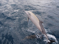 Sometime later we had a dolphin sighting by Carla. Not unusual by now but I pre-warned Carla that so far the visits had been brief in nature. No so this time! The dolphines numbered perhaps 20 and included Mums and young ones and collectively they had a ball playing in the bow wave of Pilgrim for almost 20 minutes. I took photos with the compact camera until it ran out of batteries and then went below to get my Olympus. It is surprising how hard it is to get a good shot but I managed just a couple, see left, out of perhaps 50 shots.

Hint click the Photos to enlarge
Wolves? Yep, Wolves, all this happened late in the trip bit I won’t keep you waiting: Just after rounding Double Island Point, we had just set the new course for Inskip and I was about to go below and make a cuppa. Fortunately, I lingered for a while standing on the companionway, chatting to my dozing shipmates. For reasons of pure habit I turned to look ahead just before going below and was totally shocked to see a large exposed rock with breaking surf dead aheads about 500m. What the ???. Jumping to the wheel to steer the boat away (we were on autohelm) I exclaimed that no such obstacle was on the Navionics charts! A quick cross reference to the paper chart showed the object to be Wolf Rock, a small and deadly yet prominent feature of this spot. Another lesson learned - electronic charts have limitations that must be respected. Ironically, while in Mooloolaba, I had insisted on buying paper charts as it is regulation and certainly my preference. The problem was that my cross reference was insufficient on this occasion.
 OK, the whales and dolphins: Fairly early in the trip I was staring to port when a mature whale (Southern right I think) jumped almost clear of the water only about 50 metres from the boat. Doubtlessly the most spectacular sighting to date, but we once again missed the shot as the display was so short lived. Upon my call, Paul and Carla saw the resultant splash and a number of following blows but that’s all as the single jump was the limit of the display this time.
 Sometime later we had a dolphin sighting by Carla. Not unusual by now but I pre-warned Carla that so far the visits had been brief in nature. No so this time! The dolphines numbered perhaps 20 and included Mums and young ones and collectively they had a ball playing in the bow wave of Pilgrim for almost 20 minutes. I took photos with the compact camera until it ran out of batteries and then went below to get my Olympus. It is surprising how hard it is to get a good shot but I managed just a couple, see left, out of perhaps 50 shots.

As for the trip: It was about 70% good with good speed but uncomfortable conditions most of the way. With the bulk of our time well off the coast, but the sights along rainbow beach were certainly a spectacular interlude in the setting sun as we neared Inskip. The entry to Inskip was itself OK but while the course in is deep, it is none the less disconcerting as the entry path is surrounded by breakers at reasonably close quarters.
Dropping anchor in Pelican Bay around 16:00, just inside Inskip, with a number of other cruisers, we settled into a good dinner and plan an early departure up the Great Sandy Straight tomorrow.
Thursday, June 24, 2010
Force 8
24th Jun 2010
With report of 39kts at Double Island Point and 4.5 m swells, I decided to stay put in Mooloolaba for another day. Departure now will be Friday (25th Jun).
Out of interest, 39kts is a Force 8 which is formally recognised as a gale on the beaufort (meteorological) scale. The scale only goes to 12 which is >65 kts with 15m waves and is almost unique to severe cyclones. Yee Ha! The general consensus is that 8 is bad but 9 is really serious stuff.
With report of 39kts at Double Island Point and 4.5 m swells, I decided to stay put in Mooloolaba for another day. Departure now will be Friday (25th Jun).
Out of interest, 39kts is a Force 8 which is formally recognised as a gale on the beaufort (meteorological) scale. The scale only goes to 12 which is >65 kts with 15m waves and is almost unique to severe cyclones. Yee Ha! The general consensus is that 8 is bad but 9 is really serious stuff.
Subscribe to:
Posts (Atom)
