Wolves? Yep, Wolves, all this happened late in the trip bit I won’t keep you waiting: Just after rounding Double Island Point, we had just set the new course for Inskip and I was about to go below and make a cuppa. Fortunately, I lingered for a while standing on the companionway, chatting to my dozing shipmates. For reasons of pure habit I turned to look ahead just before going below and was totally shocked to see a large exposed rock with breaking surf dead aheads about 500m. What the ???. Jumping to the wheel to steer the boat away (we were on autohelm) I exclaimed that no such obstacle was on the Navionics charts! A quick cross reference to the paper chart showed the object to be Wolf Rock, a small and deadly yet prominent feature of this spot. Another lesson learned - electronic charts have limitations that must be respected. Ironically, while in Mooloolaba, I had insisted on buying paper charts as it is regulation and certainly my preference. The problem was that my cross reference was insufficient on this occasion.
 OK, the whales and dolphins: Fairly early in the trip I was staring to port when a mature whale (Southern right I think) jumped almost clear of the water only about 50 metres from the boat. Doubtlessly the most spectacular sighting to date, but we once again missed the shot as the display was so short lived. Upon my call, Paul and Carla saw the resultant splash and a number of following blows but that’s all as the single jump was the limit of the display this time.
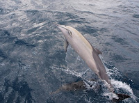
 Sometime later we had a dolphin sighting by Carla. Not unusual by now but I pre-warned Carla that so far the visits had been brief in nature. No so this time! The dolphines numbered perhaps 20 and included Mums and young ones and collectively they had a ball playing in the bow wave of Pilgrim for almost 20 minutes. I took photos with the compact camera until it ran out of batteries and then went below to get my Olympus. It is surprising how hard it is to get a good shot but I managed just a couple, see left, out of perhaps 50 shots.
As for the trip: It was about 70% good with good speed but uncomfortable conditions most of the way. With the bulk of our time well off the coast, but the sights along rainbow beach were certainly a spectacular interlude in the setting sun as we neared Inskip. The entry to Inskip was itself OK but while the course in is deep, it is none the less disconcerting as the entry path is surrounded by breakers at reasonably close quarters.
Dropping anchor in Pelican Bay around 16:00, just inside Inskip, with a number of other cruisers, we settled into a good dinner and plan an early departure up the Great Sandy Straight tomorrow.


No comments:
Post a Comment